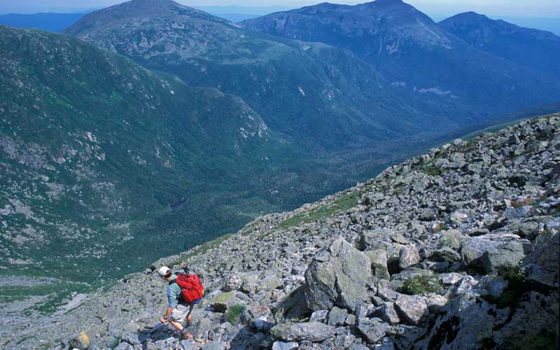
Want to climb the highest peak in the Northeast the hard way? The Great Gulf Trail follows the West Branch of the Peabody River through a Wilderness Area and then ascends New Hampshire’s iconic Mount Washington via an infamously precipitous headwall.
The Great Gulf Trail begins at the Great Gulf Wilderness parking area on the west side of Route 16. The trail runs 7.4 miles from the parking area to a junction just below the summit. Most hikers like to take two days to complete the trek. There are some designated backcountry campsites; otherwise, campsites must be at least 200 feet away from the trail (and camping is prohibited within a quarter mile of the trail above the junction with Sphinx Trail).
The route is beautiful and lightly trafficked, alternately following the river closely and retreating into the woods. Though the hiking is fairly easy up to the headwall, there are several brook crossings along the way that can be difficult in high water.
Some sections of trail in the Great Gulf were blazed as early as 1881, but no continuous, maintained Great Gulf Trail existed until an AMC trail-blazing party set to work in 1908. The team constructed the entire trail, along close to its present route, in just six days.
At the end of its first day of work, the tired party rested atop a steep, gravelly bank about 2.5 miles down the trail from the current parking area, enjoying an incredible view of the Gulf and surrounding mountains. One worker wrote, “The semicircular wall of mountains from this point, at evening, seem but a few hundred yards distant. That view is destined to become famous.” They named the spot The Proscenium, for the forepart of a stage, although now it’s known simply as The Bluff.
Past The Bluff, trail highlights include a suspension bridge over the West Branch, a large glacial erratic named Clam Rock for its shape, and a stretch that climbs wet, slippery ledges alongside several beautiful cascades, including Weetamoo Cascade. At 6.5 miles, the trail reaches Spaulding Lake, a small mountain tarn. The Great Gulf itself is a cirque, an amphitheater-shaped valley with steep walls carved by glacial erosion.
Soon after the lake, you’ll face the headwall. The climb is rocky and steep, rising 1,600 feet in just 0.8 mile. Be careful here: Rocks can be loose or unstable, and winter snow slides often wash away the cairns marking the trail. Your hard work will be well rewarded by spectacular views of the Gulf and the Presidential Range on clear days. Once you’ve made it to the top of the headwall, it’s another 0.4 mile to the summit of Mount Washington via Gulfside Trail and Trinity Heights Connector.
There are many ways down from the summit. You could follow the Mt. Washington Auto Road to Wamsutta Trail or Chandler Brook Trail, both of which rejoin Great Gulf Trail below the headwall.
Distance: 7.8 miles to the summit
Info: White Mountain Guide, 29th ed. (AMC Books); White Mountain Guide Online; wilderness.net
Champlain Mountain | Acadia National Park, Maine
Acadia’s most challenging climb, Precipice Trail, ascends Champlain Mountain over large boulder talus and some sheer faces with ladders and iron rungs. In spring and summer, Precipice may be closed to protect reintroduced peregrine falcons, which nest nearby. For another nearby, exposed hike with ladders, head to the Beehive Trail just 0.2 mile up Bowl Trail (0.7 miles to summit of The Beehive), and loop back via Bowl Trail to Sand Beach.
Distance: 1.3 miles to summit of Champlain Mountain via Precipice Trail; 1.4 miles loop up Beehive to Sand Beach.
Info: Maine Mountain Guide, 10th ed. (AMC Books)
Katahdin | Baxter State Park, Maine
Knife Edge is an exposed, serrated granite ridge connecting Pamola Peak to South Peak on Katahdin. On its north side, a steep cliff drops 2,000 feet into South Basin, and in some places the ridge narrows to only 2 or 3 feet wide. For a 10-mile loop, take the Helon Taylor Trail, cross Knife Edge to Saddle Trail, and return via Chimney Pond Trail.
Distance: Knife Edge 1.1 miles; loop 10 miles
Info: Maine Mountain Guide, 10th ed. (AMC Books)
Ice Gulch | Randolph, N.H.
Ice Gulch has some of the most challenging terrain in the White Mountains. The ravine’s east-west orientation keeps much of it out of direct sunlight, creating a cool microclimate with the stunted trees and sparse vegetation of a mountain peak. As you scramble up a talus of jagged, slippery boulders, look in crevices for blocks of ice that often persist into summer. Hike up Ice Gulch Path and loop back via Cook Path.
Distance: 6.0 miles
Info: White Mountain Guide, 29th ed. (AMC Books); White Mountain Guide Online; New Hampshire National Heritage Bureau
Mount Colden | Essex County, N.Y.
Begin on the primary trail, which starts at the end of Adirondack Loj Road, and take a left toward Avalanche Pass at the secondary trailhead. The trail passes Avalanche Lake, with lots of rock scrambling and ladders, and steeply descends to Colden Lake before a strenuous ascent to the summit of Mount Colden. Make a loop with both trails for a challenging hike of almost 15 miles.
Distance: 14.75 miles round-trip
Info: Lake Placid/Essex County Convention and Visitors Bureau
Devil’s Path | Green County, N.Y.
Expect the going to be very slow and daunting on Devil’s Path, which spans over 25 miles of up-and-down hiking in the Catskills. For a tough day hike, begin at the trailhead off NY 23A in Tannersville and summit Indian Head. Watch out for unexpected perilous ledges.
Distance: 3.8 miles to summit of Indian Head
Info: Catskill Mountain Guide, 3rd ed. (AMC Books)
CONTRIBUTORS: Mike Dickerman, Peter W. Kick, Carey Kish, Susan Rose, Steve Smith
